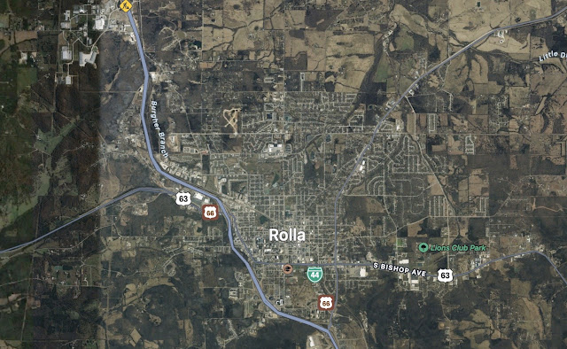
There is a lot you can work out from maps and satellite photos on google. I have already established that Rolla was a quite a small town in 1861. It still is - population c. 20,000 today. The Court House was roofed but unfinished in 1861 which is presumably why the Union were able to use it as warehouse and hospital during the early part of the war. There are a handful of heritage buildings in Rolla but apart from the courthouse it would appear wooden built. Main Street is barely 200 m long and there are a few other gridded roads from old photos. It is wonderful bringing an old place back to life.
The picture below is the town in 1860. Maybe a handful of two story buildings only. A hotel and one or two grander houses and stores in town. Towards the edge of town just simple single story two or three room wooden houses. There is probably some warehousing and facilities for the railroad terminus in the photo (the railroad planned to reach San Francisco from St.Louis ended here in 1861).
Above : Historic Photo of City of Rolla (see footer)
I don't think the town will need more than one Volley and Bayonet 6 inch x 4 inch template (An area 600 m x 400 m in ground scale). I have found a few more pictures of heritage buildings on public sites online. The courthouse : -
An old wooden schoolhouse :-
And the County Jail block from the early Nineteenth century :-
The road plan reveals an "Old St. James Road" leading on to St. Louis. From the map I have been able to find other old roads leading at different points of the compass to the nearby locations of Vichy, Salem and to Yancy Mills. The area is much more wooded than I expected with numbers of watercourses. It's possible that these might be seasonal given one of the names - "Little Dry Creek". I have been able to place some high ground to the North and West of the town, probably from where the photo above might have been taken. There are some tree lines along the old watercourses and a few farms. Out come the coloured pencils and some common sense and can think back to this roughly 3 mile x 2 mile or 6 x 4 foot table for Rolla in 1861.
The names of the tributary streams display the part German heritage of the town - "Franz Branch" and "Burgher Branch" e.g. The aerial photo shows that the irrigated sections that are not hilly or wooded are densely marked out with square land claim plots. This original land claim parcelling is thrown forward into the more recent land use. So for example a local golf is crammed entirely into a square plot that must have been bought originally as farmland. The same holds true for housing developments that fit to the square "claims" pattern out into the farmland surrounding the historic town. You just don't get that grid pattern of land use in the UK. In the US it is is extended into the farmland itself.


No comments:
Post a Comment